Gippsland Basin resource and land use planning model
Gippsland Basin preliminary model
 As part of the Victoria Gas Program (VGP), a resource and land use planning model was developed for the Gippsland Basin using a multi-criteria analysis. The methodology is outlined at the resource and land use planning webpage. The preliminary model and methodology were tested with the VGP’s independent Stakeholder Advisory Panel, and then with Gippsland local government planners, representatives from the Traditional Owner Corporation and other state government agencies in March 2020 to ensure relevant data was captured.
Consultation in Gippsland
Community consultation saw a total of 150 people participate in ten online public workshops in early June 2020. The workshops provided residents in the Gippsland Basin with an opportunity to share their local knowledge, values and insights that could be added to the model. Eight sessions captured insights from the different local government areas within the study area: Wellington, South Gippsland, East Gippsland and Latrobe. Two region-wide workshops were also held.
Common feedback included site locations of environmental features, such as endangered and vulnerable flora and fauna, as well as locations of certified organic farms, or scenic views and vistas.
Final onshore Gippsland basin model
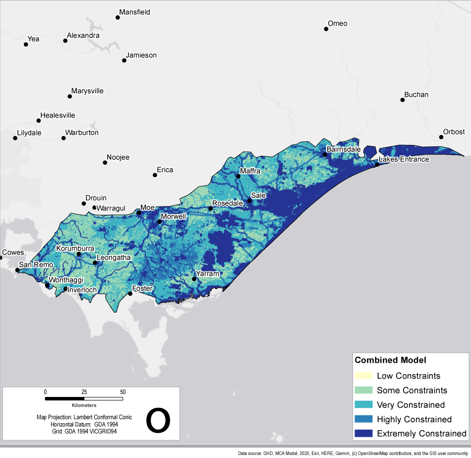
The final model (Figure 1) provides a visualisation of land uses and landscape sensitivities across Gippsland and demonstrates constraints and opportunities for potential multi and sequential land use.
The model indicates that there are no areas without some level of constraint in the Gippsland Basin. Therefore, all areas require appropriate planning and management (as set out in Victoria’s petroleum regulations) if gas development were to take place.
Areas and/or features identified in the model as highly or extremely constrained include:
- areas with restrictive topographical features, such as extreme slope
- areas already prohibited or restricted through existing legislation, such as national parks and other Crown land reserves
- areas within and surrounding townships, such as residential zones and urban growth areas
- areas along rivers and near water bodies and coastal areas
- vegetation, habitat or species of environmental importance
- cultural heritage or landscape values of significance
- productive significant agricultural land defined through strategic planning documents or planning schemes
- existing/future infrastructure such as water and gas pipeline footprints, wind and solar farms, waste facilities and quarries
- areas with higher exposure to natural or environmental hazards such as bushfire, flood, areas prone to sea level rise, or extreme heat.
The model is dynamic and can be built on and reanalysed as required. Any potential future onshore conventional gas exploration and development can be informed by this regional assessment.
A technical report about the Gippsland Basin Resource and Land Use Planning model can be found on the Gippsland Basin technical reports webpage .
Further information
- Resource and Land Use Planning Frequently Asked Questions
- Information about the preliminary Otway Basin Resource and Land Use Planning model.
- A fact sheet developed for the Resource and Land Use Planning community workshops can be viewed below.
Page last updated: 10 Feb 2023
