Eastern Victoria Geoscience Initiative
Program update
The next component of the Eastern Victoria Geoscience Initiative commenced in August 2023.
The Shepparton Numurkah Regional Ground Gravity Survey will collect over 20,000 data readings of variations in the Earth’s natural gravity field. The survey is occurring along public roadsides and will take about 12 months to complete.
The Eastern Victoria Geoscience Initiative began mapping the Victorian component of the Southeast Lachlan Crustal Transect in 2018. The aim of the project is to improve understanding of southeast Australia’s underlying geological ‘architecture’ from the surface to approximately 60 kilometres deep within the Earth.
The Initiative includes the acquisition of fundamental geoscience datasets and applied geoscientific research. The findings will assist government to make better informed land management decisions to benefit the community, identify natural geological hazards, protect state infrastructure and manage earth resources.
The scientific results of Victoria’s project will be married up with results from a similar operation in southeast New South Wales, providing a key geological reference for southeast Australia in terms of the geology and how it has evolved over the past 500 million years. Read more about the geology of eastern Victoria.
Mapping the Southeast Lachlan Crustal Transect is a collaborative effort; it involves the Geological Survey of Victoria, Geoscience Australia, the Geological Survey of New South Wales and AuScope Limited (utilising funds provided via the National Collaborative Research Infrastructure Strategy).
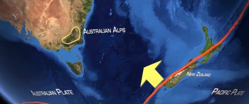
An essential component of the scientific research program across Victoria and New South Wales is the collection and interpretation of deep crustal seismic reflection data through the Australian Alps.
A preliminary interpretation of the deep crustal seismic data is currently being developed by project partners. It incorporates geological observations and knowledge obtained over the past 60 years. The interpretation will then be strengthened by new geoscience data from recent ground gravity and magnetotelluric surveys along the survey route and will be presented as a final interpretation incorporating a new 3D geological model for southeast Australia.
Watch the Beneath the Australian Alps film
The Geological Survey of Victoria commissioned a short film describing the seismic surveying activities and preliminary geological interpretation.
Watch the Beneath the Australian Alps film on Youtube.
Southeast Lachlan Crustal Transect
Geological survey work across the Southeast Lachlan Crustal Transect is being conducted in the eastern highlands of Victoria and in southeast New South Wales; from Benalla, Victoria to east of Cooma, NSW and from Benambra, Victoria to near Eden, NSW. The routes for completed and planned surveys are marked on the map below.

The survey routes follow local roads and tracks, passing through Crown land, some national parks, and a small number of private properties. Arrangements are made with property owners and land managers on a case-by-case basis prior to any ground activities taking place.
Surveying and results
The fundamental regional geoscience datasets acquired across the Southeast Lachlan Crustal Transect will enable researchers to better understand the underlying geological 'architecture' of eastern Victoria, with further surveying work planned for 2020. These datasets include:
- The Southeast Lachlan Deep Crustal Seismic Reflection Survey (acquired in 2018)
- The Southeast Lachlan Ground Gravity Survey (acquired in 2019)
- The Southeast Lachlan Magnetotelluric Survey (on hold due to COVID-19)
Experienced specialist contractors will carry out these surveys under the supervision of the project partners.
Survey results from the Eastern Victoria Geoscience Initiative will be incorporated into existing state and national public geoscience databases. All survey results, data compilations, interpretations and new models will be made publicly available on this website and the Geoscience Australia website.
Southeast Lachlan Deep Crustal Seismic Reflection Survey
Raw and processed data from the Southeast Lachlan Deep Crustal Seismic Reflection Survey are available from Geoscience Australia as L208 Southeast Lachlan Seismic Survey 2018.
A detailed report describing the Southeast Lachlan Deep Crustal Seismic Reflection Survey data acquisition and preliminary interpretation is being prepared by the project partners as:
CAYLEY, R.A., SKLADZIEN, P.B., CAIRNS, C.P., HAYDON, S.J., MCLEAN, M.A., TAYLOR, D.H., FOMIN, T., COSTELLOE, R.D., KIRKBY, A.L., DUAN, J., DOUBLIER, M.P., MUSGRAVE, R.J., STOLZ, E.M., SPAMPINATO, G., GILMORE, P.G., GREENFIELD, J.E. & RAWLING, T.J., In Prep. Preliminary geological interpretation of deep 2D seismic reflection survey lines 18GA-SL1, 18GA-SL2 and 18GA-SL3 undertaken as part of the Southeast Lachlan Crustal Transect. Geological Survey of Victoria, Geological Survey of New South Wales.
The report and summary of findings will be available from this website.
Southeast Lachlan Ground Gravity Survey
Survey results from the Southeast Lachlan Ground Gravity Survey are available from Geoscience Australia as South East Lachlan Gravity point data.
A report describing survey operations is currently being prepared by the project partners.
Is this research looking for mineral deposits or petroleum resources?
This research is not looking for mineral deposits. It is being conducted to improve scientific understanding of the regional geology and of how it has evolved over time at a large scale. The survey techniques cannot directly detect minerals. However, minerals such as gold are known in parts of the region and the results of the research may potentially provide a larger context for how these mineral deposits might have formed over time.
The areas to be surveyed are not prospective for oil, gas, or coal. These resources require a different type of geology that is not present in northeast Victoria.
The research has nothing to do with unconventional gas or fracking, which have been banned in Victoria.
Printable fact sheets
More information
- Download the raw and processed deep crustal seismic reflection data from GeoScience Australia as L208 Southeast Lachlan Seismic Survey 2018 (18GA-SL1, 18GA-SL2, 18GA-SL3).
- Download the point located ground gravity data from Geoscience Australia as South East Lachlan Gravity point data (Geoscience Australia Project No. P201930).
- Find out more about deep crustal seismic surveys across Australia.
- Find out more about gravity as a geophysical technique.
- Find out more about the magnetotelluric scientific method including examples from previous projects across the Australia.
Contact us
- P: 136 186
- E: evgi.info@deeca.vic.gov.au
Page last updated: 12 Apr 2024