Southeast Lachlan Deep Crustal Seismic Reflection Survey
The Geological Survey of Victoria (GSV) conducted a low impact regional deep crustal seismic reflection survey in northeast Victoria, during March and April 2018.
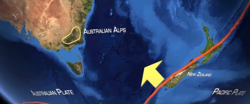
The survey is the first of its kind acquired across the Australian Alps. It completes a near-continuous deep crustal seismic transect across southeast Australia from Naracoorte in South Australia, through Victoria, to Eden on the coast of New South Wales.
The survey is part of a government-funded collaborative scientific research program. It was carried out in collaboration with Geoscience Australia, Geological Survey of New South Wales and AuScope (utilising funds provided under the NCRIS program).
The seismic data has been processed and a preliminary geological interpretation by the project partners is being finalised. The Eastern Victoria Geoscience Initiative (EVGI) page provides a summary of work completed, in progress and planned.
Find out how a deep seismic reflection survey works and view a short film showcasing the seismic survey from conception, through acquisition to interpretation.
Watch the Beneath the Australian Alps film
The Geological Survey of Victoria commissioned a short film describing the seismic surveying activities and preliminary geological interpretation.
Watch the Beneath the Australian Alps film on Youtube.
Seismic data acquisition phase
From March to April 2018 a convoy of survey trucks moved slowly through the Australian Alps along three routes:
- Line 1 started south of Benalla and covered approximately 306 kilometres eastwards towards Tom Groggin.
- Line 2 began north of Benambra and ended after approximately 154 kilometres near Bonang.
- Line 3 started west of Bonang and passed through Bendoc, continuing east to the coast south of Eden in New South Wales.
These routes are marked in purple on the below map.

The survey covered a total of 629 kilometres across challenging and varied terrain not normally traversed by seismic acquisition in Australia and took 48 days to complete.
The seismic survey convoy consisted of four AHV-IV vibroseis trucks, approximately 3,000 Smart Solo Geophones, up to 40 technical staff, mobile processing and geophone offices, a mobile camp and numerous support vehicles.
Seismic data processing and preliminary interpretation phase
After completion of data acquisition, the seismic data needs to be processed before it can be interpreted. Images are created that show the size and location of the seismic reflections from rock deep within the Earth. The deep crustal seismic reflection data collected during the 2018 survey is shown below and is available fromGeoscience Australia.
A summary of data acquisition and processing for the survey was presented as a paper (PDF 184 kB) at the 2019 Australian Exploration Geoscience Conference in Perth.
 from south of Benalla (left) to west of Tom Groggin (right).<br />Click image to view a larger version.")
 from north of Benambra (left) to southeast of Bonang (right); Right panel Line3 (18GA-SL3) from west of Bonang (left) to south of Eden (right).<br />Click image to view a larger version.")
During February 2019, the project collaborators met and considered the new seismic data together with existing geoscience data along the survey route. An example of the results of this meeting and further research by project members is the first geological interpretation of Lines 1 to 3 (18GA-SL1, 18GA-SL2, 18GA-SL3) shown below. These results were presented as posters and a paper (PDF 184 kB) at “Discoveries in the Tasmanides 2019” in Wagga Wagga, NSW.
A detailed report describing the Southeast Lachlan Deep Crustal Seismic Reflection Survey data acquisition and preliminary interpretation is being prepared by the project partners with publication due in 2021.
 from south of Benalla (left) to west of Tom Groggin (right).<br />Click image to view a larger version.")
 from north of Benambra (left) to southeast of Bonang (right); Right panel Line3 (18GA-SL3) from west of Bonang (left) to south of Eden (right).<br />Click image to view a larger version.")

Faults in red and rock packages as coloured blocks, MOHO as green line. Rock package labels coincide with the Geological Survey of Victoria’s Seamless Geology, Geological Unit 250K layers (Download the 3D Victoria Report 14 - 3D Victoria final report by Rawling, T.J., Osborne, C.R., McLean, M.A., Skladzien, P.B., Cayley, R.A. & Williams, B., 2011).
Further work
The new information derived from the seismic datasets provides an opportunity to refine and update the existing 3D geological models in eastern Victoria and southeast New South Wales.
Modelling of new detailed ground gravity and magnetotelluric data together with existing airborne magnetic and regional ground gravity datasets provides additional information about the physical properties of rocks hidden within the Earth’s crust and will be used to improve the geological understanding of the Southeast Lachlan Crustal Transect and surrounds.
Geoscience researchers can use this new, high quality, publicly available dataset to further develop understanding of southeast Australia’s underlying geological ’architecture’ and how it has evolved over the past 500 million years.
Frequently asked questions
Under Victorian laws, surveyors engaged by the Geological Survey of Victoria (GSV) were given the right to carry out this research. This seismic survey was authorised under Section 112 (1) of the Mineral Resources (Sustainable Development) Act 1990.
The seismic survey work was overseen by the department. A range of other Victorian government authorities were been consulted, such as Parks Victoria, the Department of Environment, Land, Water and Planning, VicRoads and local councils.
No. Three Vibroseis trucks drove slowly in convoy along the survey route, stopping at frequent intervals to generate the seismic signal by synchronously vibrating the ground beneath them for 10 to 15 seconds. The vibrations were about the same as those generated by a large truck driving past.
Three trucks were required to generate sufficient seismic energy to see deep into the earth. The trucks were pre-programmed so that vibrations were only generated at the pre-determined points. The vibrations were generated clear of buildings and significant infrastructure.
The highly sensitive geophones were embedded in the surface to a depth of approximately 100-150 millimetres to minimise the detection of noise on the surface when listening for the echoes from great depth.
The survey sites were chosen by scientists where more data is needed to understand the region’s geology and how it has evolved over time.
The survey lines were designed across the region to be as straight as possible to achieve the best scientific result.
The data will be incorporated into the existing state and national seismic databases. It will be used by the Geological Survey of Victoria (GSV) to help build a publicly available, digital three-dimensional (3D) geological model to increase understanding of the region’s geology and to present this information visually.
The new data will complement existing data from previous surveys in the region and help build an understanding of how eastern Victoria has evolved over time.
Yes. The Geological Survey has safely carried out deep seismic reflection surveys using the same techniques across all of Victoria, including central and western Victoria in 2006 and 2009 respectively, to help build up an understanding of how the geology of Victoria has evolved over time.
This survey was conducted to improve scientists’ understanding of the geology of the region and of how it has evolved over time.
The technique cannot directly detect minerals. Minerals are known in the region and the results of the survey may potentially provide context for how these minerals have formed over time.
No. This survey was carried out to better understand the geology of eastern Victoria (and southeast Australia) and how it has evolved over time.
The area to be surveyed is not prospective for oil and gas. The survey has nothing to do with fracking.
The results of this survey will be publicly available through Geoscience Australia’s website and through the Geological Survey of Victoria (GSV).
More information
- View and download printable fact sheets describing the geology of eastern Victoria and survey work undertaken as part of the Eastern Victoria Geoscience Initiative.
- Discover how a deep seismic reflection survey works
- Find out more about deep crustal seismic surveys across Australia on the Geoscience Australia website
- View the raw deep crustal seismic reflection data on the Geoscience Australia website
Page last updated: 13 Jul 2022